


In November 2025, the Center for Sea Survey and Mapping (SEAMAP) completed the side-scan sonar survey in the coastal area of An Giang province (formerly Kien Giang province). This was the work of the task “Investigation and surveying, establishment of topographic maps of coastal wetland areas in the three provinces of Nam Dinh, Khanh Hoa, and Kien Giang” under the Project: “Application of surveying and mapping technology in investigation, assessment of the current status, inventory and proposal of solutions for conservation and sustainable use of coastal and island wetland areas (pilot for 3 representative coastal and island areas of Vietnam)” which Seamap has been carrying out since the beginning of 2024.
The characteristics of survey area are vast, shallow water depths ranging from approximately 2m to 6m, and numerous obstacles caused by construction, transportation, aquaculture, and fishing activities. Conducting side-scan sonar surveys is extremely challenging. Based on years of experience in implementing numerous side-scan sonar survey projects for offshore constructions such as: the underwater power cable project to Co To Island in 2012, Phu Quoc Island in 2013, Ly Son Island in 2014, Cai Chien Island, Can Gio Island, and Tran Island; Sonar scanning for construction, monitoring, and maintenance of wind turbine foundations, power lines, pipelines, drilling rig foundations, and offshore structures… Seamap implemented innovative and effective solutions to ensure the technical aspects and progress of the work, such as selecting scanning times with high tide levels, designing suitable run-lines to minimize wave impact, and using safe equipment deployment methods…
After two years of continuous survey, Seamap conducted seabed image scans covering a vast area of over 1,500 km2 along the coast of three provinces: Nam Dinh, Khanh Hoa, and Kien Giang (formerly known as the old provinces). Combined with high-density seabed sampling in the scanned area, the project’s output provides a detailed and accurate view of the seabed surface in waters with depths ranging from 2 m to 6 m. This has significantly contributed to the investigation, assessment, determination of the current status, and inventory of coastal and island wetlands, as well as the establishment of base maps classifying wetland types within the range from the lowest average sea level over many years to -6m in the three provinces where the project is being implemented.
Side-Scan is a technology for image scan from 2 sides of a sonar fish. Simultaneously emitting pulsed sound signals, called pings, in a fan-shaped pattern on either side are transmitted and received.
Reflected signals appear when sound waves encounters a reflection boundary, which is the boundary between two layers with different wave resistances ρ = σV, where σ is the density and V is the speed of sound propagation. The distance to the object is calculated by multiplying the reflection time by the speed of sound in water (approximately 1420 m/s) and dividing by 2. Due to the low transmission power and high transmission frequency, the device is set to receive the reflected signal at a frequency range that only receives the single reflected wave in the direction of the beam. The boundary encountered is the boundary of a mass with a density different from that of water, in this case the seabed and objects on the seabed, possibly including suspended objects can be detected.
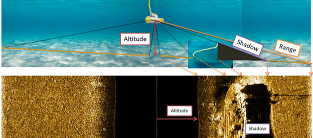
Image: Illustration of a working Side Scan Sonar device.
When a beam of radio waves, emitted at an angle, encounters an object or landform that is elevated above its surroundings, it reflects back. The area on the side of the elevated object that neither receives the transmitted signal nor receives the reflected signal is called the shadow region. By measuring the size of the shadow region and the angle of inclination of the reflected wave, the height of the landform can be calculated.
Besides object shadow measurement techniques to detect features elevations, the technique of analyzing reflected waves is also applied in Side Scan Sonar technology to differentiate seabed surface areas with different seabed materials.
Based on the characteristics of the reflective surface, seabed materials can be classified.
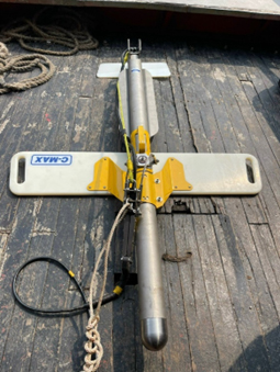
Photo: Side Scan Sonar C-MAX CM2 device of the Seamap
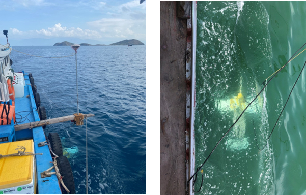
Photo: Side Scan Sonar equipment in operation in shallow coastal waters.
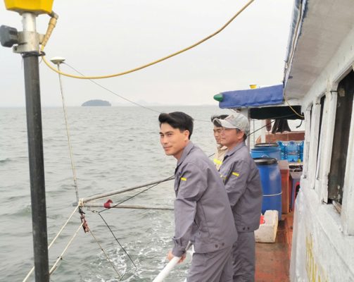
Photo: SEAMAP’s technical staff carrying out work on a survey vessel in the coastal area of An Giang province (formerly Kien Giang province).
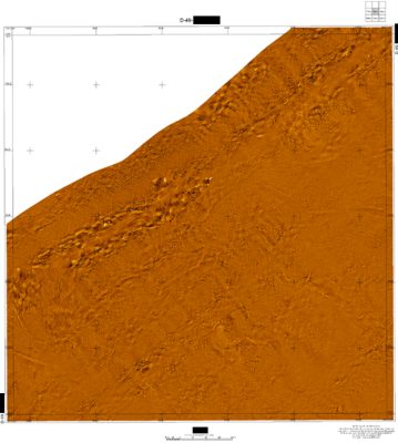
Image: A sonar mapping product

Image: Aquaculture cages submerged within the Side Scan Sonar measurement area are clearly shown on the product
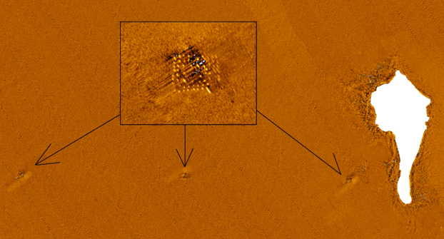
Photo: The concrete foundation of the power poles driven into the seabed from the mainland to Phu Quoc Island, located within the survey area (near Hon Mong Tay, white background), is clearly shown in the product.
The timely completion of the coastal sonar scanning mission in Nam Dinh, Khanh Hoa, and Kien Giang (formerly known as the old provinces) and the high-quality results affirm SEAMAP’s professional capabilities and expertise, demonstrating its mastery of modern technology from the design phase, data collection, processing, and analysis, while also solidifying Seamap’s position in the surveying industry.
With the successes achieved in the pilot project, it can be affirmed that the application of Side Scan Sonar is a crucial mark in the work of “Assessing the current status, inventorying, and proposing solutions for the conservation and sustainable use of coastal and island wetlands.” In the coming time, the nationwide implementation to fulfill the tasks at point c, clause 1, Article 31 of Government Decree No. 66/2019/ND-CP dated July 29, 2019, on the conservation and sustainable use of wetlands will be a very large and challenging undertaking, but it also promises to be an opportunity for SEAMAP to continue to assert itself and maintain the trust of its managing unit, Department of Survey, Mapping and Geographic Information of Vietnam, and higher authorities, as well as customers and partners in the process of providing services.