Skip to content
Trung tâm Trắc địa và Bản đồ Biển – SEAMAPTrung tâm Trắc địa và Bản đồ Biển – SEAMAP
  • |
  • HOME
  • INTRODUCTION
    • GENERAL INTRODUCTION
    • FOUNDATION HISTORY
    • ORGANIZATION CHART
    • FUNCTIONS AND TASKS
    • AFFILIATES
  • SERVICES
    • TYPICAL PROJECTS
    • EQUIPMENT
    • SOFTWARE
    • SERVICES
  • NEWS
  • PICTURE STORE
  • CONTACT
  • Seamap Webmail
  • 9
FORMATION HISTORY

22
Th11
Gói Thầu Số 2 – Dự án đầu tư xây dựng Tuyến đường sắt đô thị SỐ 1 TP.HCM TUYẾN BẾN THÀNH – SUỐI TIÊN

Dự án Đầu Tư Xây Dựng Tuyến Đường Sắt Đô Thị số 1 Thành Phố

19
Th11
Sản phẩm bản đồ biển Việt Nam 1:50000; 1:10000; 1:5000

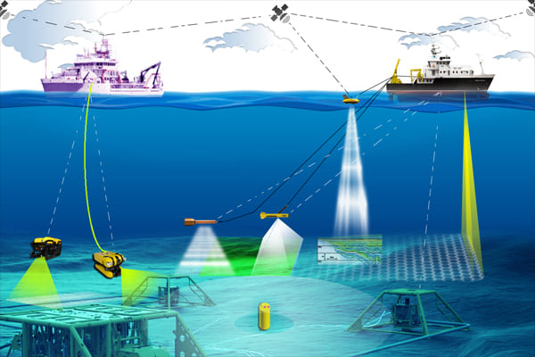
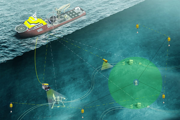
Bên cạnh các sản phẩm dịch vụ, các sản phẩm điển hình Seamap với tiêu

05
Th11
GENERAL INTRODUCTION

30
Th10
Organization Chart

30
Th10
Survey for the construction of offshore structures

15
Th10
Advice, technology training and transfer

12
Th10
Underwater positioning (USBL, LBL)

11
Th10
Positioning and Navigation

11
Th10
SubSea Gyro/ Motion Sensor – iXBlue OCtans 3000 and TSS series

11
Th10
  • 1
  • …
  • 3
  • 4
  • 5
  • 6
  • 7
  • 8
  • 9
  • 10
Danh mục
  • Decisions (6)
  • Equipment (32)
    • Hydrographic Equipment (20)
    • Other Equipment (8)
    • Positioning Equipment (9)
  • Independent Units (4)
  • Introduction (7)
  • Labratory (1)
    • Documents (1)
  • Legal Documents (6)
  • News (34)
    • Activities (2)
    • Activity News (8)
    • Events (7)
    • Hot News (21)
    • Projects (1)
    • Technology (1)
  • Seamap (6)
  • Services (6)
  • Software (7)
  • Typical Projects (14)
    • Site Survey (7)
    • Thành lập Bản đồ (4)
    • Typical Projects (2)
    • USBL underwater positioning (1)
VIDEO TIÊU BIỂU
https://youtu.be/R68s6v7OIMA


CENTER FOR SEA SURVEY AND MAPPING
28 Pham Van Dong R., Dich Vong Hau ward, Cau Giay Dist., Hà Nội.
TL: (+84) +24 37547194
FAX: (+84) +24 37547365
Email: contact@seamap.com.vn
Website: english.seamap.com.vn

DEPENDENT UNITS:
Northern Sea Survey Division
Add: 79 Nguyen Chi Thanh, Dong Đa, HN

Southern Sea Survey Division
Add:  30 Road No. 3, Quarter 4, An Khanh ward, Thu Duc city, HCMC

Survey and Mapping Services Division
Add: 126A Do Luong R., ward 11, Vungtau city

PUBLIC SURVEY SERVICES PROVISION:
Sea surface positioning and navigation
Underwater USBL positioning
Survey and seabed topographic mapping
Bathymetry, Sub-bottom and seabed image scanning for pre-feasibility study, construction, installation, repair, maintenance of offshore topside and underwater structures
Land survey, sinking monitoring and mapping

Follow me!
Share me!
  • |
  • HOME
  • INTRODUCTION
    • GENERAL INTRODUCTION
    • FOUNDATION HISTORY
    • ORGANIZATION CHART
    • FUNCTIONS AND TASKS
    • AFFILIATES
  • SERVICES
    • TYPICAL PROJECTS
    • EQUIPMENT
    • SOFTWARE
    • SERVICES
  • NEWS
  • PICTURE STORE
  • CONTACT